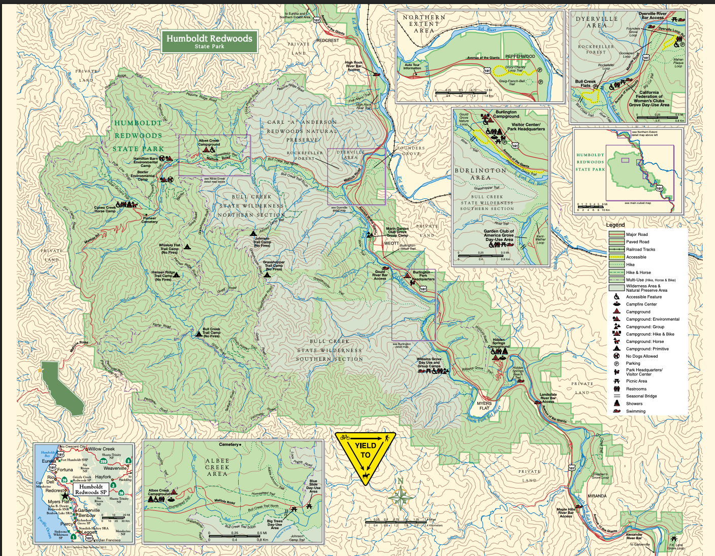
Thirty-one miles of old road threading through Humboldt Redwoods State Park — called the finest forest drive in the world, and free. Here are the stops, hikes, and river time worth planning for.
Length
31 miles
Cost
Free
No stops
1 hour
Done properly
A full day
Share this guide
Send the route and trail notes to your travel group.
The Avenue is a stretch of the original highway, built as a wagon and stagecoach route in the 1880s. When US-101 was rebuilt alongside it, the old road stayed exactly where it was — going through the trees instead of around them.
Avenues, groves, trailheads, river stops and both entrances at a glance.
It is mostly flat with gentle curves, passing secluded forest hamlets, campgrounds, picnic areas and access points to the Eel River — a federally designated Wild and Scenic waterway with swimming, fishing and paddling.
The park covers about 53,000 acres and holds roughly 17,000 acres of old growth, including Rockefeller Forest: the largest continuous stretch of old-growth coast redwood left anywhere on earth.
On foot
The hikes, with real numbers
The drive is the famous part, but you do not understand the scale until you are standing under it. These routes run from half an hour to a very long day.
Drury–Chaney Loop
Mile marker 43.9, just south of Pepperwood
Distance
2.4 mi
Time
1 hr 15
Climb
Flat
Easy
A level stem heads west from the Avenue and opens into a loop at the far end. Expect flat, well-graded tread through a forest floor carpeted in redwood sorrel.
The first thing you reach driving down from Arcata, and five minutes of the stem is enough to get the point.
Founders Grove & Mahan Loop
Mile marker 20.5, 4.1 mi north of park HQ
Distance
0.7–1.5 mi
Time
30–60 min
Climb
Flat
Easy
The self-guided loop passes the Founders Tree and the fallen Dyerville Giant — 362 feet of redwood that came down in 1991. Mahan Loop connects directly off the south side.
Walking beside a fallen giant conveys the scale better than standing under a living one.
Rockefeller Grove Loop
1.1 mi west on Mattole Road
Distance
0.6 mi
Time
30 min
Climb
Flat
Easy
A flat loop through Lower Bull Creek Flat inside ten thousand acres of Rockefeller Forest, the largest unbroken old-growth redwood forest on the planet.
Arguably better trees than Founders with a fraction of the people.
Bull Creek Flats
Lower Bull Creek Flats, Mattole Road
Distance
7.5 mi loop
Time
4 hrs
Climb
500 ft
Moderate
A long but almost level loop through the heart of Rockefeller Forest, using trails on both banks of Bull Creek and a seasonal footbridge to close the circuit.
The bridge is the planning problem; outside the season, walk one bank as an out-and-back.
Stephens Grove Loop
Mile marker 7.0, north of Miranda
Distance
Short loop
Time
30 min
Climb
Flat
Easy
An elongated loop through old growth between the road and river, with parking straight off the Avenue and a cutoff across the middle.
A good choice if you are staying in Miranda or Myers Flat.
Grasshopper Peak
Grasshopper Multi-use Trail, Mattole Road
Distance
13.4 mi
Time
8 hrs
Climb
3,100 ft
Strenuous
A long, steady climb from the valley floor to a former fire lookout with views over the whole park.
For fit hikers with a whole day: start early, carry water, and tell someone your plan.
Gould Grove Nature Trail
Six-tenths of a mile, level, interpretive, and ADA accessible. Starts directly across the road from the visitor center.
Johnson Prairie
2.2 miles with 600 feet of climb to a prairie with a clear view of Grasshopper Peak.
The whole road
Every stop, in driving order
Coming from Arcata? You will drive north to south. These stops are shown in that order, from Pepperwood to Phillipsville.
1
North entrance — Pepperwood
US-101 exit 674. Coming south from Arcata or Eureka, this is where you leave the freeway.
Entrance
US-101 exit 674
2
Drury-Chaney Grove
A 2.4-mile flat loop through sorrel-carpeted forest. The best nature trail on the Avenue and the first thing you reach from the north.
2.4 mi loop
Flat
Low crowds
3
Immortal Tree — Redcrest
A roadside veteran that survived fire, flood, logging and a lightning strike. Carved markers show the flood high-water lines.
Roadside
5 minutes
4
Rockefeller Forest & Bull Creek
Turn west on Mattole Road into ten thousand acres of old growth. The Rockefeller Loop is 0.6 flat miles; Bull Creek Flats runs much further.
Detour
Best trees
Hikes
5
Founders Grove
The half-mile loop past the Founders Tree and the fallen Dyerville Giant. Turn onto Dyerville Loop Road for the car park.
0.5 mi loop
Restrooms
Busy midday
6
Dyerville Lookout
Picnic tables where the South Fork meets the main Eel. Dyerville was a stagecoach stop until the 1955 flood took the town off the map.
Picnic
History
7
Humboldt Redwoods Visitor Center
At Burlington: current trail conditions, road closures, maps, restrooms and the Redwood Log of History.
Restrooms
Maps
Worth 10 min
8
Women’s Federation Grove
A four-sided stone hearth designed by Julia Morgan sits beside the South Fork of the Eel, with a swimming hole nearby.
Swimming
Architecture
Underrated
9
Williams Grove
Day-use area with river access, picnic tables and room to spread out — a practical lunch stop.
Picnic
River access
10
Shrine Drive-Thru Tree — Myers Flat
One of only three drive-thru trees in Northern California and the only one on the Avenue. Small fee; the photo is the point.
Small fee
Cars only
Kids
11
Stephens Grove & Miranda
A short, quiet old-growth walk near a small town with a market and food options.
Short walk
Food
Services
12
South entrance — Phillipsville
US-101 exit 645. Coming up from the Bay Area or Garberville, start here.
Entrance
US-101 exit 645
The other half
The Eel River
The Avenue follows a federally designated Wild and Scenic river, and on a hot summer day the water is as much the point as the trees.
The swimming hole beside the hearth at Women’s Federation Grove is the best-known, and Williams Grove has easy river access with picnic tables. Summer levels drop enough for calm wading in many stretches.
In summer, the river makes a welcome break from the road.
Levels change fast. What is placid in August can be dangerous in spring runoff.
The water is cold, even in high summer.
Bring water shoes; the riverbed is cobble, not sand.
Fishing and paddling are possible — check current regulations and conditions with the visitor center.
The big question
Avenue of the Giants or Redwood National Park?
The common mix-up in Northern California trip planning: these are different places, roughly two and a half hours apart, and both are worth seeing.
Question
Avenue of the Giants
Redwood National & State Parks
Where
Southern Humboldt, around Weott and Myers Flat
Northern Humboldt and Del Norte, Orick to Crescent City
Experience
A drive with enormous trees from the car and short loops off it.
A set of parks; drive between trailheads and walk more.
Best for
Limited mobility, short time, and the classic road-through-redwoods photo.
Hiking, Fern Canyon, elk, wild coastline, and tallest trees.
Time needed
An hour to a full day.
A full day minimum, two to do it justice.
Planning
How much time do you have?
1 hour
Passing through
Exit at Pepperwood and drive the road.
Stop at Founders Grove.
Walk the half-mile loop.
Rejoin US-101.
Still worth doing
Half day
The proper visit
Walk Drury-Chaney from the north.
See Founders Grove and the Dyerville Giant.
Stop at Burlington visitor center.
Walk Rockefeller Loop.
Choose one roadside oddity on the way out.
What most people should do
Full day
All of it
Drive the full 31 miles with the brochure.
Walk Bull Creek Flats in Rockefeller Forest.
Lunch and swim at Women’s Federation Grove.
Visit Big Trees Day Use Area.
Try the drive-thru tree if there are kids.
Best with a base in the south
Practical
Before you drive it
RVs and trailers are welcome. The road is closed to commercial big rigs but fine for campers; take curves slowly.
Grab the free brochure at either end. It maps the numbered Auto Tour stops.
Cell service is patchy. Download maps before you leave US-101.
Food is thin on the road. Miranda and Myers Flat have most of it, so pack lunch from Arcata.
Fog and drizzle improve it. A grey day is not a wasted day.
Winter brings closures and removes seasonal footbridges at Bull Creek.
There is no entry fee anywhere on the Avenue; a few private roadside attractions charge a small amount.
Where to stay
Two houses near the Avenue
Lodging in southern Humboldt is limited and books out spring through fall. These two put you on the road rather than an hour from it.
Avenue of the Giants · Eel River Valley
Cliff House
Mid-century modern on eight private acres above the Eel River, with six bedrooms, a hot tub, a gas fire pit and an Evo cooktop. Pets welcome.
An earth-built straw-bale dome on a hilltop above Benbow, with a treehouse casita, a hot-tub gazebo and an outdoor kitchen. Fifteen minutes from the Avenue.